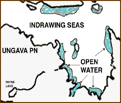
The open water marvels shown on this drawing of Ungava Bay were derived from Fig. 7 of The Frozen Echo by Seaver, 1996. Fig. 7 is a view of Davis Strait from a satellite photograph by ESSA-VIII in February 1995. Fig. 7 was xeroxed directly from The Frozen Echo book. The Xerox was then scanned into PhotoShop and cropped to show only Ungava Bay. The open-water marvel detail was scaled to match the map above and aligned using Akpatok Island at the base point. Finally the outlines of the open-water marvels, as shown by the satellite, were drawn onto the map. Open-water marvels Reason Home |